Back الصفيحة الصومالية Arabic Somali plitəsi Azerbaijani Сомалийска плоча Bulgarian Somalijska ploča BS Placa somali Catalan Somaliaplatte German Placa somalí Spanish Somalia Plaka Basque صفحه سومالی Persian Plaque somalienne French
| Somali Plate | |
|---|---|
 | |
| Type | Minor |
| Approximate area | 16,700,000 km2[1] |
| Movement1 | south-east |
| Speed1 | 6 mm/year |
| Features | East Africa, Madagascar, Indian Ocean |
| 1Relative to the African Plate | |
Preview warning: Page using Template:Infobox tectonic plate with unknown parameter "alt"
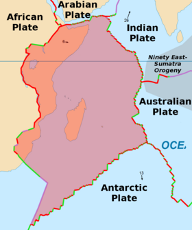
The Somali Plate is a minor tectonic plate which straddles the Equator in the Eastern Hemisphere. It is currently in the process of separating from the African Plate along the East African Rift Valley. It is approximately centered on the island of Madagascar and includes about half of the east coast of Africa, from the Gulf of Aden in the north through the East African Rift Valley. The southern boundary with the Nubian-African Plate is a diffuse plate boundary consisting of the Lwandle Plate.[2]
- ^ Alden, Andrew (2017-03-17) Here Are the Sizes of Tectonic or Lithospheric Plates. thoughtco.com
- ^ Saria, E; Calais, E.; Stamps, D.S.; Delvaux, D.; Hartnady, C.J.H. (20 March 2014). "Present-day Kinematics of the East African Rift". Journal of Geophysical Research: Solid Earth. 119 (4): 3584–3600. Bibcode:2014JGRB..119.3584S. CiteSeerX 10.1.1.723.5337. doi:10.1002/2013JB010901. S2CID 128891002.
© MMXXIII Rich X Search. We shall prevail. All rights reserved. Rich X Search